Nagaland: the land behind the languages
You cannot really explain Nagaland's languages without explaining Nagaland. A small, steep, densely forested state where neighbouring valleys developed mutually unintelligible speech, and where a trade creole became the thing that holds daily communication together.
Where it is and how it is arranged
Nagaland sits in the far north-east of India, bordered by Arunachal Pradesh to the north, Assam to the west, Manipur to the south and Myanmar to the east. The capital is Kohima; the largest urban area is the twin city of Chümoukedima–Dimapur, which is also the state's only substantial stretch of flat land and its commercial gateway.
The state is divided into administrative districts, several of them created recently: Tseminyü, for instance, was carved out of Kohima district in 2021. Vehicle registration codes track the districts: NL-01 is Kohima, NL-07 is Dimapur, and so on, which is a small everyday reminder of how district identity works here.
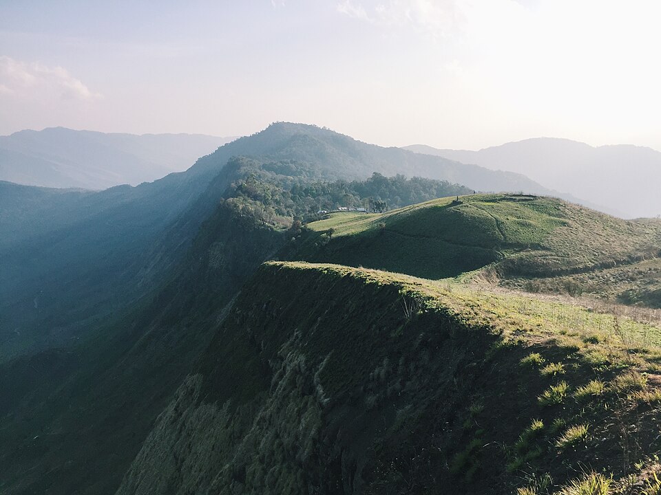
It is a mountain state. The Dzükou Valley, on the Nagaland–Manipur boundary south of Kohima, is the best-known landscape feature, reached on foot from Viswema or Jakhama after driving out from Kohima. The terrain is the underlying reason for the linguistic diversity: communities separated by a day's walk over a ridge diverge quickly, and stay diverged.
People and languages
Nagaland is inhabited by a large number of Naga ethnic groups, each with distinct customs, dress and language. The languages are overwhelmingly Sino-Tibetan, and they are not dialects of one another in any useful sense: Ao and Sümi speakers cannot understand each other without a shared third language.
That third language is usually Nagamese, an Assamese-lexified creole that grew out of hill–plains trade and now functions as the state lingua franca. English is the official language and is widely used in education, administration and print. Most people in Nagaland operate in at least three languages daily: their community language at home, Nagamese in public, and English in writing.
For a group-by-group breakdown, see the tribes of Nagaland and their languages. For the creole itself, see the Nagamese guide.
A very short history
The origin of the word "Naga" is not settled. What is documented is that Naga communities were established in the present-day hills well before the Ahom arrival in Assam in 1228 CE, organised as village states across their respective mountain territories: a political form that shaped both the languages and the fortification vocabulary you still find in them.
The nineteenth century brought British administration and American Baptist missionaries, and the two together produced the written form of most Naga languages. Missionary printing established Roman orthography, translated scripture, and (indirectly) created the first standardised written registers for languages that had until then been entirely oral.
In 1944, Kohima was the site of one of the decisive battles of the Burma campaign, when British and Indian forces halted the Japanese advance. The Kohima War Cemetery remains, with commemorations held for the dead of both sides. Nagaland became the sixteenth state of the Indian Union on 1 December 1963.
The decades that followed included a long period of insurgency and negotiated ceasefires, a history that Nagaland-based writers and speakers still discuss openly and that any visitor will encounter in conversation.
Forests, falcons and mithun
Roughly one-sixth of Nagaland is under tropical and sub-tropical evergreen forest, including palms, bamboo, rattan, and timber species. Bamboo in particular is structural to daily life: housing, tools, scaffolding, and food, since bamboo shoot is a staple ingredient cooked with pork, with fish, or on its own as chutney.
The state records more than 490 bird species. Blyth's tragopan is the state bird. Nagaland is also known as the falcon capital of the world: each autumn, hundreds of thousands of Amur falcons stop at the Doyang reservoir to feed on flying termites while migrating from China and Siberia to southern Africa. The roost was the site of a well-documented conservation turnaround, from mass hunting to community-led protection.
The state animal is the mithun (avi in Sümi), a semi-domesticated bovine that is ritually and economically the most valued animal in Nagaland: traditionally the measure of wealth and the centrepiece of a Feast of Merit, the community feast a prosperous household gives to raise its standing in the village.
The state flower is the rhododendron, which flowers red across the higher slopes.
The land of festivals
Nagaland is known within India as the Land of Festivals, and the label is earned: nearly every community has its own annual celebrations, and most of them are tied to the agricultural year rather than to a shared calendar.
| Festival | Community | When | Occasion |
|---|---|---|---|
| Moatsü | Ao | Early May | After sowing is finished |
| Tsüngremmong | Ao | August | Harvest |
| Tokhü Emong | Lotha | November | After the harvest is complete |
| Aoleang Monyu | Konyak | April | New year and the coming farming season |
| Hornbill Festival | All communities | 1–10 December | State-organised cultural festival |
The Hornbill Festival, launched by the Government of Nagaland in December 2000, is the one most visitors come for. It is held at Kisama Heritage Village outside Kohima and runs for ten days from 1 December, deliberately timed to coincide with statehood day. Each community maintains a morung: a traditional dormitory-style structure: on the grounds, and the programme covers performances, crafts, indigenous games, a food fair and traditional wrestling.
If you are going, the Hornbill Festival guide covers logistics and the phrases worth having.
Practical notes for visitors
- Permits. Indian citizens who are not residents of Nagaland have historically needed an Inner Line Permit for entry, and foreign nationals have separate registration requirements. Rules have changed several times: check the current position with the Nagaland government before travelling rather than relying on any secondary source, including this one.
- Language. English will get you a long way in Kohima and Dimapur. Nagamese will get you considerably further everywhere else, and even a handful of phrases changes how conversations go.
- Getting around. Dimapur has the airport and the railhead. Kohima is roughly two to three hours by road from Dimapur, longer in the rain. Shared taxis are the standard intercity option.
- Timing. December is festival season and also the coolest and driest month. The monsoon, roughly June to September, makes hill roads slow and landslide-prone.
Sources and further reading
Grammar descriptions on this page are drawn from the reference material listed below and from the community phrase set behind the translator. Where the sources disagree with each other, or a speaker's correction disagrees with both, the speaker's usage is followed.
- Government of Nagaland: districts, statehood and official information
- Nagaland: general background, geography and history
- NagaTranslate Nagamese conversation set: community-contributed question-and-answer pairs on Nagaland topics